Read more about the Mission below
( See Photos from the Titan II DSMP daylight launch click here!)
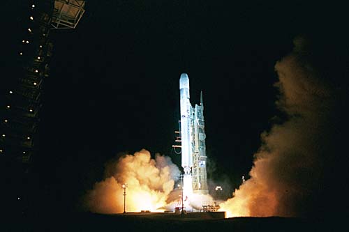
Titan II liftsoff at 3:22a.m.PDT Sept. 21, 2000 from SLC-4 West.
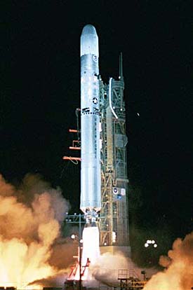
This photo was taken about 5.6 miles away and shows just how
low the cloud ceiling was at launch. On left is SLC-4E the Titan IV
pad.
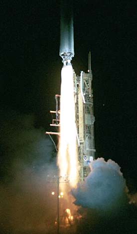
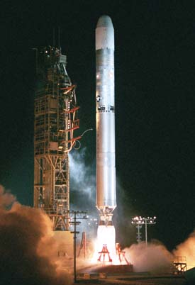
Here's a tight shot of the engines with the UT tower.
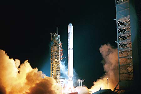
This photo was taken the with the Tower around the vehicle.
The blur on the right side is the clear door of the camera enclosure
opening.
DENVER, Colo., September 21, 2000 - The NOAA-L spacecraft, a Polar-orbiting
Operational Environmental Satellite (POES) satellite, was launched successfully
this morning at
3:22 a.m. PDT from Vandenberg Air Force Base, Calif.. Lockheed Martin Space
Systems in
Sunnyvale, Calif., built NOAA-L, and a Lockheed Martin-built Titan II space
launch vehicle,
provided under contract to the U.S. Air Force by Lockheed Martin Space
Systems in Denver,
Colo., carried the satellite into orbit.
"This
team has been totally dedicated to
providing NASA and NOAA with
satellites to extend NOAA's ability to
forecast the weather," said Al Lauer,
director of Low Earth Orbit
Meteorological Programs for Lockheed
Martin Space Systems-Missiles &
Space Operations in Sunnyvale, Calif.
"NOAA-L is the first POES spacecraft
launched in the fifth decade of this
program, and the long-standing
partnership with our NASA and NOAA
customers is a source of genuine pride
for Lockheed Martin."
"We
are very proud to be a part of this
important program for NASA, NOAA
and the U.S. Air Force," said G.
Thomas Marsh, president and general
manager of Lockheed Martin Space
Systems-Astronautics Operations, the
company that builds the Titan II launch
system. "Today's early morning liftoff marked the tenth consecutive successful
Titan II launch
and, more importantly, another successful mission for our customers."
NOAA-L
is the latest model in four generations of POES satellites. All have been
designed and
built for the National Aeronautics and Space Administration (NASA) and
the National Oceanic
and Atmospheric Administration (NOAA) by Lockheed Martin heritage companies
since the
first TIROS weather satellite launch in April 1960. Most of the spacecraft
in the series have
operated far longer than originally expected, earning them a reputation
as the workhorse of the
civil space Earth-imaging inventory.
Operating
as a pair, two POES satellites orbit the planet in nearly north-south paths.
As the
Earth rotates, the entire globe, one swath at a time, rolls into view of
the satellites' instruments.
The instruments continually sense the entire depth of the atmosphere and
report on the following
weather generating factors:
Atmosphere Temperatures and Moisture Soundings
Sea-surface Temperatures
Land-surface Temperatures
Cloud Cover and Heights
Precipitable Moisture
Total Ozone
Clear Radiance
Incoming and Radiated Heat
Together
these data comprise irreplaceable inputs to the numerical weather forecast
model and
are vital to medium and long-range forecasting. Separately or in combination,
the data are
utilized to produce sea-surface temperature maps, ice condition charts,
snow cover analysis,
vegetation maps and other forecasting and management tools.
Additionally,
NOAA-L carries an enhanced complement of microwave instruments for the
generation of temperature, moisture, surface, and hydrological products
in cloudy regions where
visible and infrared instruments have decreased capability. NOAA-L also
carries search and
rescue instruments that are used internationally for locating ships, aircraft,
and people in distress.
The use of satellites in search and rescue has been instrumental in saving
more than 11,354 lives
since the inception of the Search and Rescue Satellite-aided Tracking (SARSAT)
system.
The
NOAA-L satellite will operate in a circular, near-polar orbit of 470 nautical
miles above the
Earth with an inclination angle of 98.744 degrees to the equator. Its orbital
period, which is the
time it takes to complete one orbit of the Earth, will be approximately
102 minutes.
The
NOAA-L nominal orbit is Sun-synchronous and rotates eastward about the
Earth's polar
axis 0.986 degrees each day, approximately the same rate and direction
as the Earth's average
daily rotation about the Sun. The rotation keeps the satellite in a constant
position with reference
to the Sun for constant scene illumination throughout the year.
NASA's
Goddard Space Flight Center, Greenbelt, Md., is responsible for the procurement,
development, launch services, and verification testing of the spacecraft,
instruments, and unique
ground equipment. Following deployment of the spacecraft from the launch
vehicle, Goddard is
responsible for the mission operation phase leading to injection of the
satellite into orbit and
initial in-orbit satellite checkout and evaluation.
Following
the launch and a comprehensive on-orbit verification period that lasts
45 days,
NASA will turn operational control of the satellites over to NOAA. NOAA
will operate the
satellites from the Satellite Operations Control Center of the National
Environmental Satellite,
Data, and Information Service in Suitland, Md., along with the nation's
other environmental
satellites that it operates.
NOAA's
environmental satellite system is composed of two types of satellites:
geostationary
operational environmental satellites (GOES) for national, regional, short-range
warning and
"now-casting"; and polar-orbiting environmental satellites (POES) for global,
long-term
forecasting and environmental monitoring. Both GOES and POES are necessary
for providing a
complete global weather monitoring system. Both also carry search and rescue
instruments to
relay signals from aviators and mariners in distress.
In
addition, NOAA operates satellites in the Defense Meteorological Satellite
Program
(DMSP), which are also polar-orbiting satellites. NOAA also manages the
processing and
distribution of the millions of bits of data and images the GOES and POES
satellites produce
each day.
On
May 5, 1994, President Clinton made the landmark decision to merge the
nation's military
and civil polar-orbiting operational meteorological satellite systems into
a single, national system
capable of satisfying both civil and national security requirements for
space-based remotely
sensed environmental data. The new system is called the National Polar-orbiting
Operational
Environmental Satellite System, or NPOESS. Convergence of the civil and
military programs is
the most significant change in U.S. operational remote sensing since the
launch of the first
weather satellite.
The
first converged satellite is expected to be available for launch in the
latter half of the decade,
approximately 2009, depending on when the remaining POES and DMSP program
satellite
assets are exhausted.
Titan
II intercontinental ballistic missiles (ICBMs) served as the vanguard of
our nation's
strategic deterrent for more than two decades. In the late 1960s, 10 Titan
IIs also successfully
launched astronauts as part of the Gemini program. When the Titan II ICBMs
were
decommissioned, the U.S. Air Force Space and Missile Systems Center, Los
Angeles, Calif.,
contracted with Lockheed Martin to refurbish 14 for use as space launch
vehicles. Today's
launch was the tenth consecutive successful launch of a Titan II space
launch vehicle.
Astronautics
and Missiles & Space are two of the operating units of Lockheed Martin's
Space
Systems business area. Astronautics designs, develops, tests and manufactures
a variety of
advanced technology systems for space and defense. Chief products include
space launch
systems, planetary spacecraft and other space systems and ground systems.
Missiles & Space is
a leading supplier of satellites to military, civil government and commercial
communications
organizations around the world. These spacecraft have enhanced military
and civilian
communications; provided new, extensive and timely weather data; studied
the Earth and space;
and furnished new data for thousands of scientists studying our planet
and the space around it.
Return to Space Photography Page